2019 Cruises
| CTD Processing Summary CalCOFI 1902RL CTD FINAL Data | |||
| Download 1902RL CTD raw cast files zipped | Download 1902RL FINAL CTD + bottle data | ||
|
General CTD Notes - data acquisition notes, logistics, processing - see below. |
|||
| CTD sensor corrections derived by comparing CTD sensor data, 4sec averages prior-to-bottle closure, to bottle samples | |||
| Dual T, S, & O2 | Primary Sensor | Secondary Sensor | |
| Salinity offset (bottle - CTD salinity; > 350m only; Seabird SBE4) | 0.0010 | -0.0044 | |
| Oxygen ml/L (dual Seabird SBE43) |
y = 1.0484x + 0.0164 R² = 0.9998 |
y = 1.0779x + 0.0441 R² = 0.9997 |
|
| Oxygen umol/Kg (dual Seabird SBE43) |
y =1.0486x + 0.7276 R² = 0.9998 |
y = 1.0781x + 1.9354 R² = 0.9996 |
|
| Single sensors | Linear | Polynomial | |
|
Nitrate - ISUS 4sec ave voltage vs Bottle NO3 (Satlantic ISUS v3 SNMBARI-ISUS; NEW LAMP) |
y = 27.543x - 24.379 R² = 0.956 |
Note: ISUS lamp was replaced, burn-in drift will be dealt with by regressing individual casts vs bottle NO3 samples - see individual plots. | |
| Fluorometer - linear & polynomial regressions |
y= 11.664x - 0.4473 R² = 0.8618 |
y = 14.443x2+ 7.3964x - 0.2501 R² = 0.8826 **used for calculations |
|
 |
 |
||
 |
 |
||
 |
 |
||
Platform: NOAA Ship Reuben Lasker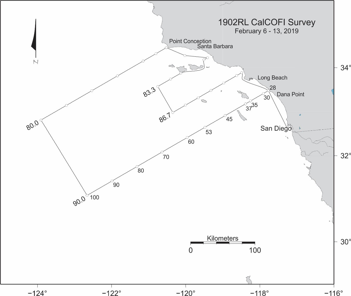
Project Number: RL-19-01 (OMAO), 1902RL (SWFSC)
Project Title: Winter CalCOFI, Fisheries Resources Division.
Project Dates: February 6, 2019 to February 13, 2019
Project Instructions: (Complete PDF)
- Overview
- Brief Summary and Project Period
Survey the distributions and abundances of pelagic fish stocks, their prey, and their biotic and abiotic environments in the area of the California Current between San Francisco, California and San Diego, California during the period of February 6 to February 13, 2019.
- Days at Sea (DAS)
Of the 8 DAS scheduled for this project, 8 are funded by a Line Office Allocation. This project is estimated to exhibit a High Operational Tempo.
- Operating Area
The area covered during this survey will be from San Diego to Point Conception and extend approximately 200 miles offshore (please see appendix section).
- Summary of Objectives
Survey the distributions and abundances of pelagic fish stocks, their prey, and their biotic and abiotic environments in the area of the California Current between Point Conception, California and San Diego, California.
The following are specific objectives for the winter CalCOFI.
I.D.1. Continuously sample pelagic fish eggs using the Continuous Underway Fish Egg Sampler (CUFES). The data will be used to estimate the distributions and abundances of spawning hake, anchovy, mackerel, and early spawning Pacific sardine.
I.D.2. Continuously sample multi-frequency acoustic backscatter using the Simrad EK60/80 and the Simrad ME80. The data will be used to estimate the distributions and abundances of coastal pelagic fishes (e.g., sardine, anchovy, and mackerel), and krill species (please see appendix section).
I.D.3. Continuously sample sea-surface temperature, salinity, and chlorophyll-a using a thermosalinometer and fluorometer. These data will be used to estimate the physical oceanographic habitats for target species.
I.D.4. Continuously sample air temperature, barometric pressure, and wind speed and direction using an integrated weather station.
I.D.5. Sample profiles of seawater temperature, salinity, chlorophyll-a, nutrients, and phytoplankton using a CTD with water-sampling rosette and other instruments at prescribed stations. Measurements of extracted chlorophyll and phaeophytin will be obtained with a fluorometer. Primary production will be measured as C14 uptake in a six hour in situ incubation. Nutrients will be measured with an auto-analyzer.
I.D.6. Sample the light intensity in the photic zone using a standard secchi disk in conjunction with a daytime CTD station. These data will be used to interpret the measurements of primary production.
I.D.7. Sample plankton using a CalBOBL (CalCOFI Bongo Oblique) at prescribed stations. These data will be used to estimate the distributions and abundances of ichthyoplankton and zooplankton species.
I.D.8. Sample plankton using a Manta (neuston) net at prescribed stations. These data will be used to estimate the distributions and abundances of ichthyoplankton species.
I.D.9. Sample the vertically integrated abundance of fish eggs using a Pairovet net at prescribed stations. These data will be used to quantify the abundances and distributions of fish eggs.
I.D.10. Sample plankton using a PRPOOS (Planktonic Rate Processes in Oligotrophic Ocean Systems) net at all prescribed CalCOFI stations on lines 90.0 and 80.0 as well as stations out to and including station 70.0 on lines 86.7 and 83.3 and station 81.8 46.9. These data will be used in analyses by the LTER (Long Term Ecological Research) project.
I.D.11. Continuously sample profiles of currents using the RDI/Teledyne Acoustic Doppler Current Profiler. This will be dependent on the ability to sync the ADCP’s output with the EK60 and ME70. The EK60 and ME70 will hold priority over the ADCP (please see appendix section).
I.D.12. Continuously observe, during daylight hours, seabirds and mammals. These data will be used to estimate the distributions and abundances of seabirds and marine mammals.
- Participating Institutions
I.E.1 Southwest Fisheries Science Center (SWFSC)
I.E.2 Scripps Institution of Oceanography (SIO)
I.E.3 Farallon Institute Advanced Ecosystem Research (FIAER)
| Project: | CalCOFI 1902RL (UNOLS RL1901) |
| Summary: |
CalCOFI's original January winter cruise was postponed by the government shutdown. With the ship's impeding dry dock schedule and another possible government shutdown Feb 15th, our winter cruise was compressed into 8 days at sea. Core stations on Line 90 & 80 out to 100 were the focus. Additional stations on Lines 83 (83.3) & 87 (86.7) out to station 60 were planned, time-permitting. We were able to occupy 29 of 31 stations, dropping 83.60 & 87.60 due to lack of shiptime. All station work - CTD-rosette; Bongo, Pairovet, PRPOOS, Manta Net tows; NCOG & DIC sampling were performed. The deepest casts were in Santa Monica Basin to 715m & Santa Barbara Basin to 565m. Primary productivity incubation experiments were not performed this cruise so no prodo data will be available. |
| Data Files: |
1902RL CTD Cast Files, 1902RL Preliminary CTD+Bottle Data Files (preliminary anomaly plots will NOT be presented due to gaps in the data) |
| Announcement: |
CalCOFI |
| Cruise Dates: | Wednesday, 06 Feb 2019 - Wednesday, 13 Feb 2019 |
| Loading: | Mon Dec 17th - Thu Dec 20th 2018 early load & setup, with continued loading & setup Mon-Tue 4-5 Feb 2019 at 10th Ave Marine Terminal*, San Diego, CA. Sail date 0900 06 Feb 2019. *Entry to 10th Ave Marine Terminal & RV Reuben Lasker requires a TWIC card or escort. |
| Offloading: | Thursday, 14 Feb 2019; 10th Ave Marine Terminal, San Diego, CA |
| Partiicpant Forms: | NOAA Medical Forms - required for all cruise participants sailing Jan 05 2019 |
| Ship: | RV Reuben Lasker |
| Station plan: | 31 Stations |
| Cruise Map: |
 |
| Contacts: | Bryan Overcash, Chief Scientist, NMFS |
| Dan Schuller, IOD (SIO Technical Coordinator) | |
| CTD Processing Summary CalCOFI 1904RL CTD Final Data | |||
| Download 1904RL CTD raw cast files zipped | Download 1904RL Final CTD + bottle data | ||
|
General CTD Notes - data acquisition notes, logistics, processing - see below. |
|||
| CTD sensor corrections derived by comparing CTD sensor data, 4sec averages prior-to-bottle closure, to bottle samples | |||
| Dual T, S, & O2 | Primary Sensor | Secondary Sensor | |
| Salinity offset (bottle - CTD salinity; > 350m only; Seabird SBE4) | -0.00218 | 0.002378 | |
| Oxygen ml/L (dual Seabird SBE43) |
y = 1.0277x + 0.0137 R² = 0.9996 |
y = 1.0536x + 0.0423 R² = 0.9996 |
|
| Oxygen umol/Kg (dual Seabird SBE43) |
y =1.0286x + 0.6031 R² = 0.9997 |
y = 1.0543x + 1.8765 R² = 0.9997 |
|
| Single sensors | Linear | Polynomial | |
|
Nitrate - ISUS 4sec ave voltage vs Bottle NO3 (Satlantic ISUS v3 SN111) |
y = 28.145x - 21.053 R² = 0.9956 |
||
| Fluorometer - linear & polynomial regressions |
y= 13.85x - 0.5885 |
y = 19.225x2+ 4.5721x - 0.1043 |
|
 |
 |
||
 |
 |
||
 |
 |
||
| Summary: | CalCOFI 1904RL sailed on FSV Reuben Lasker at 1230PDT 02 Apr 2019 from 10th Ave Marine Terminal San Diego. With the loss of 1.5 days and rough Spring weather, 67 stations were completed. |
| Data Files: | 1904RL CTD raw cast files zipped; 1904RL Preliminary CTD + bottle data |
| Cruise Dates: | Leg 1: 02 - 18 Apr 2019 (Tue-Thu; 17 DAS); Leg 2: 23 - 29 Apr 2019 (Tue-Mon; 7 DAS) |
| Loading: | Loading & Setup 27 Mar & 01 Apr 2019 with departure 02 Apr 2019 |
| Offloading: | 19 Apr 2019 (Fri) 10th Ave Marine Terminal San Diego |
| Partiicpant Forms: | NOAA Medical Forms - required for all cruise participants sailing 01 Apr 2019 |
| Ship: | FSV Reuben Lasker |
| Station plan: | 102 Stations (~95 CalCOFI + 6 SCCOOS); 72 southern stations (-3 SCCOOS stas: 91.7 26.4, 85.4 35.8, 81.7 43.5) & as many stations on Lines 73.3 & 70.0 as time permits |
| Cruise Map: |
 |
| Contacts: | Bryan Overcash, Chief Scientist, NMFS |
| Dan Schuller, IOD (SIO Technical Coordinator) | |
Please note that the anomalies are based on 50-year harmonics (1949-1999) and these data are 1m binavg Seasoft-processed CTD data that have not gone through thorough quality control checks or bottle corrections. They are presented to give a general impression of current conditions. Final data plots will be published after all data are processed.
| 10 & 100 meter Preliminary CTD Data & Anomaly (50yr mean) Contours (Click for larger image) | ||
 |
 |
 |
 |
 |
 |
 |
 |
 |
 |
 |
 |
 |
 |
 |
| 200 meters (Click for larger image) | ||
 |
 |
 |
 |
 |
 |
| 300 meter (Click for larger image) | ||
 |
 |
 |
 |
 |
 |
 |
 |
 |
Platform: NOAA Ship Reuben Lasker
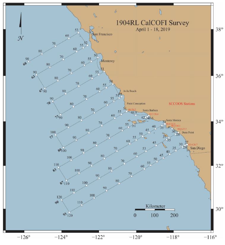
Project Number: SH-19-02 (OMAO), 1904RL (SWFSC)
Project Title: Spring CalCOFI, Fisheries Resources Division.
Gear Selectivity Trials
Project Dates: April 2, 2019 to April 29, 2019
Project Itinerary
Leg I: April 2: Depart San Diego, CA – CalCOFI
April 18: Arrive San Diego, CA & offload
Leg II: April 23: San Diego, CA – Start Gear Selectivity Trials
April 29: Arrive San Diego, CA
Project Instructions:
I. Overview
A. Brief Summary and Project Period
Survey the distributions and abundances of pelagic fish stocks, their prey, and their biotic and abiotic environments in the area of the California Current between San Francisco, California and San Diego, California during the period of April 2 to April 29, 2019.
B. Days at Sea (DAS)
Of the 24 DAS scheduled for this project, 24 are funded by a Line Office Allocation according to the Fleet Allocation Plan. This project is estimated to exhibit a High Operational Tempo.
C. Operating Area
The area covered during this survey will be from San Diego to San Francisco and extend approximately 200 miles offshore (please see Appendices 2.a. and 2.b.).
D. Summary of Objectives
Survey the distributions and abundances of pelagic fish stocks, their prey, and their biotic and abiotic environments in the area of the California Current between San Francisco, California and San Diego, California.
The following are specific objectives for the spring CalCOFI.
I.D.1. Continuously sample pelagic fish eggs using the Continuous Underway Fish Egg Sampler (CUFES). The data will be used to estimate the distributions and abundances of spawning hake, anchovy, mackerel, and Pacific sardine.
I.D.2. Continuously sample sea-surface temperature, salinity, and chlorophyll-a using a thermosalinometer and fluorometer. These data will be used to estimate the physical oceanographic habitats for target species.
I.D.3. Continuously sample air temperature, barometric pressure, and wind speed and direction using an integrated weather station.
I.D.4. Sample profiles of seawater temperature, salinity, chlorophyll-a, nutrients, and phytoplankton using a CTD with water-sampling rosette and other instruments at prescribed stations. Measurements of extracted chlorophyll and phaeophytin will be obtained with a fluorometer. Primary production will be measured as C14 uptake in a six hour in situ incubation. Nutrients will be measured with an auto-analyzer. These data will be used to estimate primary productivity and the biotic and abiotic habitats for target species.
I.D.5. Sample the light intensity in the photic zone using a standard Secchi disk at all daytime stations in conjunction with daytime CTD station. These data will be used to interpret the measurements of primary production.
I.D.6. Sample plankton using a CalBOBL (CalCOFI Bongo Oblique) at prescribed stations. These data will be used to estimate the distributions and abundances of ichthyoplankton and zooplankton species.
I.D.7. Sample plankton using a Manta (neuston) net at prescribed stations. These data will be used to estimate the distributions and abundances of ichthyoplankton species.
I.D.8. Sample the vertically integrated abundance of fish eggs using a Pairovet net at prescribed stations. These data will be used to quantify the abundances and distributions of fish eggs.
I.D.9. Sample plankton using a PRPOOS (Planktonic Rate Processes in Oligotrophic Ocean Systems) net at all prescribed CalCOFI stations on lines 90.0 and 80.0 as well as stations out to and including station 70.0 on lines 86.7 and 83.3 and station 81.8 46.9. PRPOOS will not be towed on SCCOOS stations. These data will be used in analyses by the LTER (Long Term Ecological Research) project.
I.D.10. Continuously sample profiles of currents using the RDI/Teledyne Acoustic Doppler Current Profiler.
I.D.11. Continuously observe, during daylight hours, seabirds and mammals. These data will be used to estimate the distributions and abundances of seabirds and marine mammals.
I.D.12. Gear selectivity trawl sampling using a modified Nordic 264. Trawl stations will be determined by observed CUFES egg densities and acoustic backscatter from the EK60.
I.D.13. Promoting a safe, positive and productive work environment.
All personnel that embark NOAA Ship Reuben Lasker are to fully support and comply with NOAA Administrative Order 202-1106: NOAA Sexual Assault and Sexual Harassment Prevention and Response Policy. The at-sea working/living environment is particularly sensitive and it is incumbent upon all personnel to uphold a positive and professional workplace dynamic in order to successfully accomplish cruise objectives
E. Participating Institutions
I.E.1 Southwest Fisheries Science Center (SWFSC)
I.E.2 Scripps Institution of Oceanography (SIO)
I.E.3 Farallon Institute Advanced Ecosystem Research (FIAER)
I.E.4 California Department of Fish and Wildlife (CDF&W)
II. Operations
A. Project Itinerary
Leg I: April 2: Depart San Diego, CA – CalCOFI
April 18: Arrive San Diego, CA
Leg II: April 23: San Diego, CA – Start Gear Selectivity Trials
April 29: Arrive San Diego, CA
B. Staging and Destaging
Staging and destaging will be conducted at the NOAA facility at the Tenth Avenue Marine Terminal in San Diego, CA.
We request one SWFSC MMTD Acoustic Hydraulic Winch to be craned onto the afterdeck and secured in San Diego prior to departure. Please see Appendix 3.a. Marine Mammal Acoustics Lasker Shakedown Report document for additional details. Specifications are as follows:
• Custom winch on 48" drum, 72" rim, approx 30-" wide
• Winch is attached to a larger steel based that can be bolted to the deck. Screw spacing for larger steel space is 48" (square) with the screw size of 1 5/8"
• Footprint for entire unit approximately 6'x6'
• Approximate weight (with cable): 1200 lbs
• Current motor: Sauer Danfoss DH-200 (hydraulics are engaged only when winch is actively being used (releases to neutral)
• Hansen-style quick disconnects
• PSI 1500
We request the ship to load its portable HPU unit that is currently stored in the warehouse. The portable HPU unit will be installed, as per Appendix 3.a
• 12 GPM (gals per minute of oil flow)
• 1200lb Pressure
• 440V Power, to be installed/operated on the back deck near the winch
• Water cooling system installation.
• Hydraulic hoses will be installed at the beginning of the project, and not disconnected until the end of the project. This best management practice will mitigate the leaking of hydraulic oil through the hoses.
• Efforts will be coordinated between the ship and the scientific compliment to ensure proper measures are in place to reduce environmental impacts in the event of a spill casualty.
C. Operations to be Conducted
II.C.1. Underway Operations
II.C.1.a. Thermosalinometer sampling - The ship will provide and maintain a thermosalinometer (TSG), which is calibrated and in working order, for continuous measurement of surface water temperature and salinity. A backup unit (calibrated and in working order) will also be provided by the vessel and remain aboard during the project. The Scientific Computing System (SCS) will serve as the main data collection system. All SCS data will be provided to SWFSC personnel at the completion of the project.
II.C.1.b. Acoustics: Calibration of the EK60 is not requested or planned. EK60 echosounder data will not be collected during the survey.
II.C.1.c. ADCP: The ship’s ADCP should run continuously and be logged to a data acquisition system. Complete system settings will be provided by the oceanographer, but will include 5-minute averaging of currents, AGC and 4 beam returns in 60 8-meter bins.
II.C.1.d. CUFES: The egg pump will be mounted inside the ship’s hull drawing water from a depth of three meters. The pump will run continuously between stations to sample any pelagic fish eggs. Approximately 640 liters/minute is sent through a concentrator which filters all material larger than 505μm. The sieved material is then collected and identified. All fish eggs are identified to lowest taxa, counted and entered into the data acquisition software. Each sample entry is coupled with sea surface temperature, geographical position, wind speed and direction, date and time, pump speed and surface salinity. Sampling intervals will vary in length, depending on the number of fish eggs seen, from five to 30 minutes.
It is requested that prior to departure on April 1 that the CUFES intake be cleared from all marine growth.
II.C.1.e. Bird Observations: During daylight hours a bird observer will be posted on the flying bridge to identify and count birds while the ship is underway during project transects.
II.C.1.f. Acoustic hydrophone: During transit between most daylight stations, an acoustic hydrophone array will be towed from the stern at a distance of 300 meters with a deck loaded winch to record sounds from marine mammals. The winch is a hydraulic Sauer Danfoss DH-200 with a deck pattern of 6 by 6 feet. Upon approaching a station, sonobuoys (1 – 2) will be deployed one nautical mile prior to stopping for station work.
II.C.2. Station Operations
Each standard station will include the following:
II.C.2.a. CTD/Rosette consisting of 24 10-liter hydrographic bottles will be lowered to approximately 500 meters (depth permitting) at each station to measure physical parameters and collect water at discrete depths for analysis of: salinity, nutrients, oxygen, chlorophyll, etc.
NOTE: SIO will provide their own CTD sensor and 24 bottle (10 liter) rosette unit for use on legs I. Please record CTD deployed, CTD at depth and CTD recovered for SCS.
II.C.2.b. CalBOBL (CalCOFI Bongo): standard oblique plankton tow with 300 meters of wire out, depth permitting, using paired 505 μm mesh nets with 71 cm diameter openings. The technical requirements for this tow are: Descent wire rate of 50 meters per minute and an ascent wire rate of 20 meters per minute. All tows with ascending wire angles lower than 38° or higher than 51° in the final 100 meters of wire will be repeated. Additionally, a 45° wire angle should be closely maintained during the ascent and descent of the net frame. The port side sample will be preserved in buffered ethanol at every station.
Please record Bongo deployed and Bongo recovered for SCS.
II.C.2.c. Manta net (neuston) tow: using a 505 μm mesh net on a frame with a mouth area of 0.1333 m². Tows are 15 minutes in duration at towing speed of approximately 1.5 - 2.0 knots. Wire angles should be kept between 15° and 25°.
Please record Manta deployed and Manta recovered in SCS.
II.C.2.d. Pairovet net: will be fished from 70 meters to the surface (depth permitting) using paired 25 cm diameter 150 μm mesh nets. The technical requirements for Pairovet tows are: Descent rate of 70 meters per minute, a terminal depth time of 10 seconds and an ascent rate of 70 meters per minute. All tows with wire angles exceeding 15° during the ascent will be repeated.
Please record Pairovet deployed and Pairovet recovered for SCS.
II.C.2.e. PRPOOS (Planktonic Rate Processes in Oligotrophic Ocean Systems) net will be taken at all stations on line 90.0 and 80.0 as well as stations out to and including station 70.0 on lines 86.7 and 83.3 and station 81.8 46.9. These stations are occupied as part of the LTER (Long Term Ecological Research) project. The mesh of the PRPOOS net is 202 μm and the tow is a vertical cast up from 210 meters. The technical requirements for the PRPOOS tows are: Decent rate of 40 meters per minute, a terminal depth time of 20 seconds and an ascent rate of 50 meters per minute.
Please record PRPOOS deployed and PRPOOS recovered for SCS.
II.C.2.f. Primary productivity: at about 1100 hours on each day a primary productivity CTD cast consisting of six 10-liter hydrographic bottles (mounted on CTD frame) will be carried out. The cast arrangement will be determined by a Secchi disc observation. This cast will be in conjunction with an already scheduled station. The purpose of the cast is to collect water from six discrete depths for daily in situ productivity experiments. Measurements of extracted chlorophyll and phaeophytin will be obtained with a fluorometer. Primary production will be measured as C14 uptake in a six hour in situ incubation. Nutrients will be measured with an auto-analyzer. All radioisotope work areas will be given a wipe test before the departure of the SIO technical staff. Primary productivity on leg I after line 76.7 will not be measured.
II.C.2.g. A light meter (Secchi disk) will be used to measure the light intensity in the euphotic zone once a day with the primary productivity cast and all daytime stations.
Please record Secchi deployed and Secchi recovered for SCS.
II.C.2.h. Weather observations.
II.C.3.a. Order of Operations for each standard CalCOFI station:
1) CTD to 515 meters with 24 bottle rosette (depth permitting).
2) Secchi disk (daylight stations only, Secchi will be first prior to CTD on Primary Productivity station of the day which is typically 0900-1100). Secchi disk will not be measured on Leg I after completion of line 76.7.
3) PRPOOS net tow [lines 90.0, 86.7 (out to station 70), 83.3 (out to station 70) and 80.0 ; station 81.8 46.9]. No PRPOOS on near shore SCCOOS stations. Total of 35 stations).
4) Pairovet net tow (on all lines out to station 100 but not to include near shore SCCOOS on Leg I).
5) Manta net tow (on all stations except for near shore SCCOOS).
6) Bongo net tow (on all stations).
II.C.3.b. Plankton Nets, Oceanographic Sampling Devices, Video Camera and ROV Deployments: The SWFSC deploys a wide variety of gear to sample the
marine environment during all of their research projects. These types of gear are not considered to pose any risk to protected species and are therefore not subject to specific mitigation measures. However, the OOD and crew monitor for any unusual circumstances that may arise at a sampling site and use their professional judgment and discretion to avoid any potential risks to protected species during deployment of all research equipment.
Marine mammal watches are now a standard part of conducting fisheries research activities, particularly those that use gear (e.g., longlines and mid-water trawls) known to interact with marine mammals or that we believe have a reasonable likelihood of doing so in the future. Marine mammal watches are conducted in two ways. First, watches are conducted by lookouts (those navigating the vessel and other crew) at all times when the vessel is being operated. Second, marine mammal watches and monitoring occur for 30 minutes prior to deployment of gear, and they continue until gear is brought back on board, for longlines and mid-water trawl gear. Watches in the first category are not done by dedicated staff; these personnel primary duties as lookout according to the Rules of the Road are “maintaining a proper lookout by sight and hearing as well as by all available means appropriate in the prevailing circumstances and conditions so as to make a full appraisal of the situation and of the risk of collision.” Watches in the second category are done by dedicated scientists with no other responsibilities during the watch period. If marine mammals are sighted within 1 nm of the planned set location then the sampling station is either moved or canceled. Watch-standers record the estimated species and number of animals present and their behaviors. This information can be valuable in understanding whether some species may be attracted to vessels or gear. While underway:
We will have a bird observer on the flying bridge during all daylight transects.
We will have 1-2 marine mammal observers on the flying bridge during all daylight transects.
We will have a marine mammal acoustician with a towed hydrophone. The hydrophone will be towed off the stern at a distance of 300 meters between daylight stations. The hydrophone will be deployed while leaving a station. The hydrophone can be retrieved at ship’s full speed.
At 1 mile prior to each daylight station marine mammal observers will deploy 2 sonobuoys. The hydrophone will be retrieved at this time.
Communication will be open to bridge during all hydrophone deployments and retrievals.
II.C.4.a Leg II Standard Daytime/Nighttime Trawl Operations
Each standard nighttime station will include the following:Surface trawling: Two to four surface tows will be conducted each night. The first set will be approximately one hour after sunset, and the last set will be concluded prior to sunrise. Trawl locations will be determined based on CPS egg density, daytime CPS backscatter, and other factors. Each trawl tow will be fished on the surface for a 30-min duration at a towing speed of approximately 3.5-4.5 knots. The duration
of trawls shall be reduced only when necessary to avoid protected species or ensure the safety of the ship or its crew, in which cases a minimum duration of 30 min is preferred but may be reduced at the discretion of the CL/CS. In an attempt keep the footrope from sinking too deep during deployment, it is requested that once the tom weights are in the water, the ship's speed is increased to 3.0-3.5 knots. The trawl will be fitted with cameras and lights to observe the behaviors of target species and to assess the performance of the MMED. The catch from each tow will be processed according to the SFWSC mid-water trawl abbreviated sampling protocol. The acoustic trawl mensuration system (Simrad ITI) may be used to monitor the performance of the trawl net, but shall be secured when not in use to avoid interference with the scientific echosounders.
When possible (weather permitting), a trawl catch greater than five baskets will be lifted on to the sorting table with the ship's crane. Smaller catches can be dumped into either plastic trash cans or a fish tote.
The OOD or ST shall record the time of station arrival and departure in the SCS event logger (Button labels: Arrive Station, Depart Station) and the time that the trawl is deployed and recovered (Button labels: Shoot Doors, Net in Water, Begin Fishing (EQ), Haul Back, Net on Deck).
It is requested that the OOD note the locations and times when the acoustic sampling starts and stops each day in the SCS event logger (Button labels: Resume Transect, Break Transect) and for each transect (Button labels: Start Transect, End Transect).
Protected Species Watches
For the nighttime trawl operations, protected species (e.g. marine mammals and turtles) watches are now a standard part of conducting fisheries research activities, particularly those that use gear (e.g., long-lines and mid-water trawls) known to interact with protected species or that we believe have a reasonable likelihood of doing so in the future.
a) 30-min pre-set protected species watches
Protected species watches (visual observation) will be initiated by a designated person/s from the science party no less than 30 min prior to deployment of gear for sampling in order to determine if any protected species are near the proposed trawl set location. This watch can occur during transit leading up to arrival at the sampling station. If stations are less than 5-nmi apart (or less than a 30-min transit time at typical transit speed) then pre-set watch should be conducted for the duration of the transit. Upon arrival at a sampling station, trawl operations shall be conducted immediately except when it is necessary to conduct a bongo plankton tow or CTD deployment prior to deploying trawl gear. Protected species watches will be conducted using any binocular or monocular sighting instrument, with a means to estimate the distance to protected species during the daytime. During nighttime operations, visual observation shall be conducted using the naked eye and available vessel lighting.
b) Move-on rule
If marine mammals, sea turtles or other protected species are sighted within 1 nmi of the planned set location prior to setting the gear, the vessel will transit to a
different section of the sampling area to maintain a minimum distance of 1 nmi between the set location and estimated location of sighted protected species. If, after moving on, protected species remain within the 1-nmi exclusion zone, the CL/CS or watch leader may decide to move again or to skip the station, but in any case, may not set while protected species are in the 1-nmi exclusion radius.
c) Monitoring during trawl deployment, fishing, and retrieval
In addition to the 30 min protected species watch, visual monitoring efforts for protected species are required throughout the entire period of time that trawl gear is in the water. These watches will occur from deployment through gear retrieval and will be conducted by the watch leader, CL/CS, or other designated person/s. If protected species are sighted before the gear is fully retrieved, the most appropriate response to avoid incidental take will be determined by the professional judgment of the CL/CS, watch leader and other experienced crew as necessary. This judgment will be based on his/her past experience operating gears around marine mammals and SWFSC training sessions that will facilitate dissemination of CL/CS expertise that is used when operating in these situations (e.g., factors that contribute to marine mammal gear interactions and those that aid in successfully avoiding these events). These professional judgment decisions will be recorded in the provided visual monitoring watch logs. If trawling efforts have been suspended due to the presence of marine mammals, trawl operations may only resume when sighted protected species are estimated to be at least 1 nmi away from the trawl set location. If mammals are observed in or near the net, the trawl survey lead or CL/CS may request immediate retrieval of the net which should be done as rapidly and as safely possible so as to prevent lethal takes.
d) Data collection for visual watches
The visual monitoring watches (from 30 min prior to set through gear retrieval) and any data gathered during these watches will be recorded in the watch logs provided for each survey and in the SCS.
e) Marine mammal excluder device (MMED)
At all times, Nordic 264 trawl nets must be fitted with a marine mammal excluder device to allow marine mammals caught during trawling operations an opportunity to escape.
f) Acoustic deterrent devices
Pingers must be deployed during all trawl operations and on all types of trawl nets. Two to four pingers (3 kHz @ 135 dB, 10 kHz @ 132 dB, and 70 kHz @ 145 dB) will be placed along the footrope and/or headrope and will be tested at the conclusion of every trawl to check if they are operating properly – pinger function will be noted in the data collection watch logs.
g) Other standard trawl survey protocols
The gear will be emptied as quickly as possible upon retrieval in order to determine whether or not protected species are present.
Care will be taken when emptying the trawl to avoid damage to protected species that may be caught in the gear but are not visible during retrieval.
h) Reporting, Data Collection, and Handling Procedures for Protected Species
All protected species (marine mammals, sea turtles, seabirds, and fish) lethal and non-lethal interactions with fisheries research gear will be reported to [Protected Species Incidental Take Database (PSIT)] within 48 hours and via the Incidental Take Authorization account: This email address is being protected from spambots. You need JavaScript enabled to view it. immediately. These interactions will be immediately relayed to the SWFSC Director and Environmental Compliance Specialist. If >3 marine mammal takes, or any lethal sea turtle takes occur, call the SWFSC Director or Deputy Director immediately.
In addition, for take of marine mammals and sea turtles, the CL/CS or watch leader will call [the EC-ITA coordinator] immediately at (770-792-2802; cell – anytime) or (858-334-2863; work – daytime only) to provide a detailed report of the event. Catch of eulachon and salmon will only be reported to This email address is being protected from spambots. You need JavaScript enabled to view it. at the conclusion of every survey day; no call is necessary. Appropriate communications on all authorized takes will occur in a timely manner to allow [the EC-ITA coordinator] to report the event to the PSIT in the required 48 hours.
i) Lethal take of marine mammal or sea turtle
If a lethal take of a marine mammal or sea turtle occurs, priority should be placed on removing the animal from the gear as quickly and safely as possible so photographs and measurements can be taken according to the protocol (PSIT-002.02; Appendix 3). After documentation and sampling, the animal(s) should be wrapped in bag(s) (trash bags or provided body bag) and placed in the scientific freezer. Concurrently, as stated above, [the EC-ITA coordinator] should be notified immediately via the This email address is being protected from spambots. You need JavaScript enabled to view it. account and reported to PSIT within 48 hours. (Call Kristen Koch or Toby Garfield if >3 marine mammals or lethal sea turtle take.
j) Non-lethal take of any protected species
Priority for any non-lethal take is to release the animal as quickly as possible according to (3) Protected Species Handling instructions (below) to maximize the chances of post-release survival. First and foremost, please take into consideration safety of all crew and staff. Concurrently, as stated above, [the EC-ITA coordinator] should be notified immediately. For live or lethal takes of protected seabirds (protocol attached below), USFWS is to be notified immediately for instructions (PSIT 007.01).
k) Protected Species Handling
In general, following a "common sense" approach to handling protected species will present the best chance of minimizing injury to the animal and of decreasing risks to scientists, officers and crew. There are inherent safety concerns associated with handling/disentangling protected species, so using good judgment and ensuring human safety is paramount. SWFSC researchers should refer to PSIT-004.02 (Appendix 3), SWFSC Marine Mammal Handling Guidelines, and the Pacific Islands Region's Identification, Handling and Release of Protected Species (PSIT-005.01, Appendix 3), and SWFSC's marine mammal and sea turtle sampling protocol (PSIT-002.01, Appendix 3) for more specific guidance on protected species handling and sampling (e.g., species identification, safe removal of fishing gear, etc.).
For all marine mammal and sea turtle incidental interactions, SWFSC researchers will record interaction information using the Trawl Incidental Take Form and the Marine Mammal and Sea Turtle Specimen Data form. For any incidental takes of protected fish species (salmon, eulachon and bull trout), SWFSC researchers will fill out the Protected Fish & Seabird Specimen Data form.
l) Protected Species Sampling and Data Collection
SWFSC scientists are authorized under MMPA regulation 50 CFR 216.22 and encouraged to collect samples from authorized protected species (see Appendix 3) incidentally captured or killed during fisheries research activities. For sampling, follow guidelines in PSIT-002.02, SWFSCs Detailed Sampling Protocol for Marine Mammal and Sea Turtle Incidental Takes (Appendix 3) and fill out the Marine Mammal and Sea Turtle Biological Sampling form.
D. Dive Plan
All dives are to be conducted in accordance with the requirements and regulations of the NOAA Diving Program (http://www.ndc.noaa.gov/dr.html) and require the approval of the ship’s Commanding Officer.
A dive is requested for clearing the CUFES intake of attached mussels or marine growth.
E. Applicable Restrictions
Conditions which preclude normal operations:
In the event of poor weather conditions, we will work with the ship’s officers on developing the best strategy for completion of all stations safely.
We have replacement gear for all operations. Equipment failure should not impact our project.
Please note that the anomalies are based on 50-year harmonics (1949-1999) and these data are 1m binavg Seasoft-processed CTD data that have not gone through thorough quality control checks or bottle corrections. They are presented to give a general impression of current conditions. Final data plots will be published after all data are processed.
| 10 & 100 meter Preliminary CTD Data & Anomaly (50yr mean) Contours (Click for larger image) | ||
 |
 |
 |
 |
 |
 |
 |
 |
 |
 |
 |
 |
 |
 |
 |
| 200 meters (Click for larger image) | ||
 |
 |
 |
 |
 |
 |
| 300 meter (Click for larger image) | ||
 |
 |
 |
 |
 |
 |
 |
 |
 |
| Summary: | CalCOFI 1907BH sailed on RV Bold Horizon at 0800PDT 11 Jul 2019 from 10th Ave Marine Terminal San Diego. 70 of 75 science stations were completed. CTD casts, secchi disk casts, and various net tows were completed at each science station. Underway visual observations of marine mammals and avifauna were conducted while under transit and coupled with sonobuoy deployments at each station. Other underway science included continuous pCO2/pH and meteorological measurements. Unfortunately, approximately 12 hours were lost early in the cruise due to satellite communications malfunction. The ship diverted from the standard CalCOFI cruise track after 93.3 45.0 north to San Clemente Island to affect repairs and resumed work at 93.3 50.0. |
| Cruise Dates: | 11 - 26 Jul 2019 (Thu-Fri; 16 DAS) |
| Loading: | Loading & Setup 08 - 10 Jul 2019 with departure 11 Jul 2019 |
| Offloading: | 29 Jul 2019 (Mon) 10th Ave Marine Terminal San Diego |
| Ship: | RV Bold Horizon |
| Station plan: | 70 Stations completed (62 CalCOFI + 8 SCCOOS) |
| Cruise Map: |
 |
| Contacts: | Dan Schuller, Chief Scientist, Scripps Institution of Oceanography |

Platform: R/V Bold Horizon
Project Number: 1910BH
Project Title: CalCOFI Summer Survey
Project Dates: 11-26 July 2019
Prepared By: Daniel Schuller, Chief Scientist, Integrative Oceanography Division, Scripps Institution of Oceanography
Date Submitted: 17 June 2019
Documents:
- Cruise Instructions
- Predicted Station Schedule
- Station Activities
- Station Sampling
- Station Coordinates
I. Overview
A. Brief Summary and Project Period
Survey the distributions and abundances of pelagic fish stocks, their prey, and their biotic and abiotic environments in the area of the California Current between San Diego, California and Avila Beach, California during the period of summer 2019.
B. Operating Area
From San Diego, CA to Avila Beach, CA and out 300 nautical miles. Please refer to 1907BH-schedule.PDF for CalCOFI Line and Sta name, coordinates, and predicted order. Please note that station order may change due to weather or naval operations.
C. Summary of Objectives
Survey the distributions and abundances of pelagic fish stocks, their prey, and their biotic and abiotic environments in the area of the California Current between San Diego, California and Avila Beach, California.
I.C.1. NA
I.C.2. Continuously sample sea-surface temperature, salinity, and chlorophyll-a using a thermosalinograph. These data will be used to estimate the physical oceanographic habitats for target species.
I.C.3. Continuously sample air temperature, barometric pressure, and wind speed and direction using an integrated weather station.
I.C.4. Sample profiles of seawater temperature, salinity, chlorophyll-a, nutrients, and phytoplankton using a CTD with water-sampling rosette and other instruments at prescribed stations. Measurements of extracted chlorophyll and phaeophytin will be obtained with a fluorometer. Primary production will be measured as C14 uptake in a six hour in situ incubation. Nutrients will be measured with an auto-analyzer. These data will be used to estimate primary productivity and the biotic and abiotic habitats for target species.
I.C.5. Sample the light intensity in the photic zone using a standard secchi disk once per day in conjunction with a daytime CTD station. These data will be used to interpret the measurements of primary production.
I.C.6. Sample plankton using a CalBOBL (CalCOFI Bongo Oblique) at prescribed stations. These data will be used to estimate the distributions and abundances of ichthyoplankton and zooplankton species.
I.C.7. Sample plankton using a Manta (neuston) net at prescribed stations. These data will be used to estimate the distributions and abundances of ichthyoplankton species.
I.C.8. Sample the vertically integrated abundance of fish eggs using a Pairovet net at prescribed stations. These data will be used to quantify the abundances and distributions of fish eggs.
I.C.9. Sample plankton using a PRPOOS (Planktonic Rate Processes in Oligotrophic Ocean Systems net) at all prescribed CalCOFI stations on lines 90.0, 86.7, 83.3 and 80.0 only. These data will be used in analyses by the LTER (Long Term Ecological Research) project.
I.C.10. Continuously observe, during daylight hours, marine mammals. These data will be used to estimate the distributions and abundances of marine mammals.
D. Participating Institutions
I.D.1 Scripps Institution of Oceanography (SIO)
I.D.2 Southwest Fisheries Science Center (SWFSC)
F. Administrative
1. Points of Contacts:
Chief Scientist: Daniel Schuller 858-534-2888, 9500 Gilman Dr, Dept 0206, La Jolla, CA, 92093 (This email address is being protected from spambots. You need JavaScript enabled to view it.)
Alternate: Angela Klemmedson 858-822-0305, 9500 Gilman Dr, Dept 0206, La Jolla, CA, 92093 (This email address is being protected from spambots. You need JavaScript enabled to view it.)
2. Diplomatic Clearances N/A
3. Licenses and Permits
a. All marine mammal work is covered under a federal research permit NMFS Permit 727-1915 issued to Dr. John
Hildebrand of SIO.
b. CDFW ON April 2, 2015 to NOAA-SWFSC-FRD-Cisco Werner (SC-12372)
II. Operations
A. Project Itinerary July 8-10: Load scientific gear Tenth Ave Marine Terminal Port of San Diego (TAMT)
July 11 (Thursday) 0800: All cruise participants onboard
July 11 0800: Depart San Diego, CA
July 26 (Friday) 1600: Arrive San Diego, CA
July 29 (Monday) 0800: Unload RV Bold Horizon at TAMT
Staging and De-staging
Staging for CalCOFI requires 3 days. Final de-staging will be conducted in San Diego, CA (TAMT).
We request 2 laboratory vans to be craned onto the afterdeck and secured in San Diego prior to departure. The dimension of the NOAA van is approximately 8x10x8 feet weighing 6500 lbs. Dimensions of GP van is approximately 8x20x8 feet weighing 8500 lbs. Power requirement is 110V for NOAA van and 440V 3-phase for GP van.
Request 1 laboratory van to be craned onto the 01 deck and secured in San Diego prior to departure. The dimension of the CalCOFI van is approximately 8x10x8’ 6500 lb. 110V power requirement.
B. Operations to be conducted
II.B.1. Underway Operations
II.B.1.a. Thermosalinograph sampling - Science will provide and maintain a thermosalinograph (TSG), which is calibrated and in working order, for continuous measurement of surface water temperature and salinity.
II.B.1.b. Acoustics: NA
II.B.1.c. Acoustic hydrophone: NA. Upon approaching a station, two sonobuoys will be deployed one nautical mile prior to stopping for station work.
II.B.1.d. Expendable wave measuring drifter. NA
II.B.2. Station Operations
Each standard station will include the following:
II.B.2.a. CTD/Rosette consisting of 24 10-liter hydrographic bottles will be lowered to approximately 515 meters (depth permitting) at each station to measure physical parameters and collect water at discrete depths for analysis of: salinity, nutrients, oxygen, chlorophyll, etc.
II.B.2.b. CalBOBL (CalCOFI Bongo Oblique): standard oblique plankton tow with 300 meters of wire out, depth permitting, using paired 505 µm mesh nets with 71 cm diameter openings. The technical requirements for this tow are: Descent wire rate of 50 meters per minute and an ascent wire rate of 20 meters per minute. All tows with ascending wire angles lower than 38° or higher than 51° in the final 100 meters of wire will be repeated. Additionally, a 45° wire angle should be closely maintained during the ascent and descent of the net frame. The port side sample will be preserved in buffered ethanol at every station.
II.B.2.c. Manta net (neuston) tow: using a 505 µm mesh net on a frame with a mouth area of 0.1333 m². Tows are 15 minutes in duration at towing speed of approximately 1.5 - 2.0 knots. Wire angles should be kept between 15° and 25°.
II.B.2.d. Pairovet net: will be fished from 70 meters to the surface (depth permitting) using paired 25 cm diameter 150 µm mesh nets at all stations out to and including station 70.0. The technical requirements for Pairovet tows are: Descent rate of 70 meters per minute, a terminal depth time of 10 seconds and an ascent rate of 70 meters per minute. All tows with wire angles exceeding 15° during the ascent will be repeated.
II.B.2.e. A PRPOOS (Planktonic Rate Processes in Oligotrophic Ocean Systems) net will be taken on specific stations on line 90.0, 86.7, 83.3, and 80.0. These stations are occupied as part of the LTER (Long Term Ecological Research) project. The mesh of the PRPOOS net is 202 µm and the tow is a vertical cast up from 210 meters. The technical requirements for the PRPOOS tows are: Decent rate of 40 meters per minute, a terminal depth time of 20 seconds and an ascent rate of 50 meters per minute.
II.B.2.f. Primary productivity: at about 1100 hours on each day a primary productivity CTD cast consisting of six 10-liter hydrographic bottles (mounted on CTD frame) will be carried out. The cast arrangement will be determined by a Secchi disc observation. This cast will be in conjunction with an already scheduled station. The purpose of the cast is to collect water from six discrete depths for daily in situ productivity experiments. Measurements of extracted chlorophyll and phaeophytin will be obtained with a fluorometer. Primary production will be measured as C14 uptake in a six hour in situ incubation. Nutrients will be measured with an auto-analyzer. All radioisotope work areas will be given a wipe test before the departure of the SIO technical staff.
II.B.2.g. A light meter (Secchi disk) will be used to measure the light intensity in the euphotic zone once a day with the primary productivity cast and all daytime stations.
II.B.2.h. Weather observations.
II.B.2.i. Radiosonode balloons: NA.
II.B.3.a. Order of Operations for each standard station:
1) CTD to 515 meters with 24 bottle rosette (depth permitting).
2) Secchi disk (daylight stations only, Secchi will be first prior to CTD on Primary Productivity station of the day which is typically 0900-1100).
3) PRPOOS net tow (lines 90.0, 86.7, 83.3 and 80.0 only).
4) Pairovet net tow (on all lines out to station 70.0 but not to include near shore SCCOOS).
5) Manta net tow (on all stations except for near shore SCCOOS and stations after line 76.7).
6) Bongo net tow (on all stations).
II.B.4.a.
1) Vessel speeds are restricted on research cruises in part to reduce the risk of ship strikes with marine mammals. Transit speeds vary from 8-11 knots.
2) While underway:
We will have 2 marine mammal observers on the forward observation deck during all daylight transects.
At 1 mile prior to each daylight stationmarine mammal observers will deploy 2 sonobuoys.
C. Applicable Restrictions Conditions which preclude normal operations:
In the event of poor weather conditions, we will work with the ship’s officers on developing the best strategy for completion of all stations safely.
We have replacement gear for most operations. Equipment failure should not impact our project.
III. Equipment
A. Equipment and Capabilities provided by the ship (itemized)
We request the following systems and their associated support services, sufficient consumables, back-up units, and on-site spares. All measurement instruments are assumed to have current calibrations and we request that all pertinent calibration information be included in the data package.
Starboard hydro winch with 3/8” cable and CalCOFI block for standard Bongo, Manta, Pairovet and PRPOOS tows
Starboard forward J-frame with EM cable for standard CTD casts
Starboard J-frame w/blocks to accommodate 0.25" cable
Knudsen 12 kHz depth recorder or comparable
110V power to science van on main deck
440V power to science winch on main deck
440V power to GP van on main deck
B. Equipment and Capabilities provided by the scientists (itemized)
37% Formalin (SWFSC) Ethanol (SWFSC)
Tris buffer (SWFSC)
Sodium borate (SWFSC)
30 cc and 50 cc syringes (SWFSC)
Cannulas (SWFSC)
Pint, quart and gallon jars (SWFSC)
Inside and outside labels (SWFSC)
CalCOFI net tow data sheets (SWFSC)
71 cm CalCOFI Bongo frames (SWFSC)
71 cm CalCOFI 505 µm mesh nets (SWFSC)
CalCOFI 150 µm Pairovet nets and codends (SWFSC)
CalCOFI Pairovet frames (SWFSC)
333 µm mesh codends (SWFSC)
Digital flowmeters (SWFSC) PRPOOS frames (SIO)
170 lb PRPOOS weight (SIO)
202 µm mesh PRPOOS nets and codends (SIO)
75 lb Bongo weight (SWFSC)
100 lb hydro weight (SWFSC)
CalCOFI Manta net frames (SWFSC)
60 cm CalCOFI 505 µm mesh Manta nets (SWFSC)
Standard CalCOFI tool boxes (SWFSC)
Bucket thermometers and holders (SIO)
Hand held inclinometer for Pairovet and Bongo tows (SWFSC)
Oxygen auto-titration rig with reagents (SIO)
Oxygen flasks (SIO)
Guildline Portasal (SIO)
Salinity bottles (SIO)
Standard sea water (SIO)
Data sheets for scheduled hydrographic work (SIO)
Weather observation sheets (SIO)
Primary productivity incubation rack (SIO)
14C and other chemicals for primary productivity work (SIO)
SBE911+ CTD unit with necessary sensors (SIO)
Turner fluorometer (SIO)
90% acetone and all supplies for chlorophyll extraction (SIO)
Nutrient auto analyzer (SIO)
Chemicals for all nutrient analyses (SIO)
Laptop computer running Matlab / EAL EK60 Adaptive software (SWFSC)
Isotope van (SIO)
Winch for acoustic array (SIO)
Dissecting microscopes (SWFSC)
Sonobuoys (SIO)
V. Additional Projects
N/A
VI. Disposition of Data and Reports
A. Data Responsibilities
The Chief Scientist will receive all original data related to the project. The Chief Scientist will in turn furnish the Captain with a complete inventory listing of all data gathered by the scientific party, detailing types of operations and quantities of data prior to departing the ship if requested. All data gathered by the vessel's personnel that are desired by the Chief Scientist will be released to him, including supplementary data specimens and photos gathered by the scientific crew.
B. Pre and Post Project Meeting
Prior to departure, the Chief Scientist will conduct a meeting of the scientific party to train them in sample collection and inform them of project objectives. Some vessel protocols, e.g., meals, watches, etiquette, etc. will be presented by the ship.
VII. Miscellaneous
A. Meals and Berthing
The ship will provide meals for the scientists listed above. Meals will be served 3 times daily beginning one hour before scheduled departure, extending throughout the project, and ending two hours after the termination of the project. Since the watch schedule is split between day and night, the night watch may often miss daytime meals and will require adequate food and beverages (for example a variety of sandwich items, cheeses, fruit, milk, juices) during what are not typically meal hours. Special dietary requirements for scientific participants will be made available to the ship’s command at least seven days prior to the survey.
Berthing requirements, including number and gender of the scientific party, will be provided to the ship by the Chief Scientist. The Chief Scientist will work on a detailed berthing plan to accommodate the gender mix of the scientific party taking into consideration the current make-up of the ship’s complement. The Chief Scientist is responsible for ensuring the scientific berthing spaces are left in the condition in which they were received; for stripping bedding and linen return; and for the return of any room keys which were issued. The Chief Scientist is also responsible for the cleanliness of the laboratory spaces and the storage areas utilized by the scientific party, both during the project and at its conclusion prior to departing the ship.
B. Shipboard Safety
Wearing open-toed footwear or shoes that do not completely enclose the foot (such as sandals or clogs) outside of private berthing areas is not permitted. Steel-toed shoes are required to participate in any work dealing with suspended loads, including CTD deployments and recovery. The ship does not provide steel-toed boots. Hard hats are also required when working with suspended loads. Work vests are required when working near open railings and during small boat launch and recovery operations. Hard hats and work vests will be provided by the ship when required.
Appendices Appendix 1.a. Detailed list of Scripps Oceanography Chemicals and spill control plan.
Scripps Oceanography, CalCOFI Chemical Spill Kit List, RV Sally Ride Nov 2016
The main concern here is the 10 normal Sulfuric Acid which is secured to the bench in wooden box to prevent spill. We bring a 13.5 lbs bag of Baking soda to neutralize acid in the event of a spill. Our Radiation van has a spill kit that consists of 2 x 1/2 gallon of Safety Sorbent, the spill kits listed below were just ordered along with additional baking soda. In addition to the spill kit in the Rad van we bring 6 x 1/2gallon additional cartons of Safety Sorbent http://wyksorbents.com/anti-slip-safety-sorbent/ Safety Sorbent 8 x 1/2 gallon (http://wyksorbents.com/anti-slip-safety-sorbent/)
Sodium Bicarbonate (Arm & Hammer baking soda)
2 x 13.5 lbs bag for Acid Spills
Portable Allwik Economy Spill Kit in Yellow Bag x2 (http://www.fastenal.com/web/products/detail.ex?sku=1007705)
Vinyl gloves 20+ boxes (50-100) count
Containment bags 3 rolls of 50 each
Roll paper towels 12 each.
Appendix 1.b. See separate1907BH-schedule.PDF for station positions and predicted schedule.
| CTD Processing Summary CalCOFI 1907BH CTD Final Data | |||
| Download 1907BH CTD raw cast files zipped | Download 1907BH Final CTD + bottle data | ||
|
General CTD Notes - data acquisition notes, logistics, processing - see below. |
|||
| CTD sensor corrections derived by comparing CTD sensor data, 4sec averages prior-to-bottle closure, to bottle samples | |||
| Dual T, S, & O2 | Primary Sensor | Secondary Sensor | |
| Salinity offset (bottle - CTD salinity; > 350m only; Seabird SBE4) | -0.0033 | -0.0061 | |
| Oxygen ml/L (dual Seabird SBE43) |
y = 1.0223x - 0.0043 R² = 0.9997 |
y = 1.0334x + 0.0523 R² = 0.9997 |
|
| Oxygen umol/Kg (dual Seabird SBE43) |
y =1.0213x + 0.1182 R² = 0.9999 |
y = 1.0319x + 2.4074 R² = 0.9998 |
|
| Single sensors | Linear | Polynomial | |
|
Nitrate - ISUS 4sec ave voltage vs Bottle NO3 (Satlantic ISUS v3 SN111) |
y = 27.2958x - 27.8866 R² = 0.9929 |
||
| Fluorometer - linear & polynomial regressions |
y= 11.0834x - 0.4148 |
y = 8.9265x2+ 6.5138x - 0.1721 |
|
 |
 |
||
 |
 |
||
 |
 |
||
| Summary: | CalCOFI 1911OC sailed on RV Oceanus at 1000PDT 04 Nov 2019 from Nimitz Marine Facility San Diego. 75 of 75 science stations were completed. CTD casts, secchi disk casts, and various net tows were completed at each science station. Underway visual observations of marine mammals were conducted while under transit. There was no acoustic component (i.e., no hydrophone array or sonobuoys) to this cruise. Other underway science included continuous pCO2/pH and meteorological measurements. The ship averaged >13 knots, allowing sufficient time to complete all 75 stations and return to San Diego before schedule on 19 Nov 2019 0800PDT. |
| Cruise Dates: | 04 - 19 Nov 2019 (Mon-Tue; 16 DAS) |
| Loading: | Loading & Setup 02 - 03 Nov 2019 with departure 04 Nov 2019 |
| Offloading: | 20 Nov 2019 (Wed) Nimitz Marine Facility San Diego |
| Ship: | RV Oceanus |
| Station plan: | 75 Stations completed (66 CalCOFI + 9 SCCOOS) |
| Cruise Map: |
 |
| Contacts: |
Dave Faber, Chief Scientist, SIO Angela Klemmedson, Technical Coordinator, SIO |