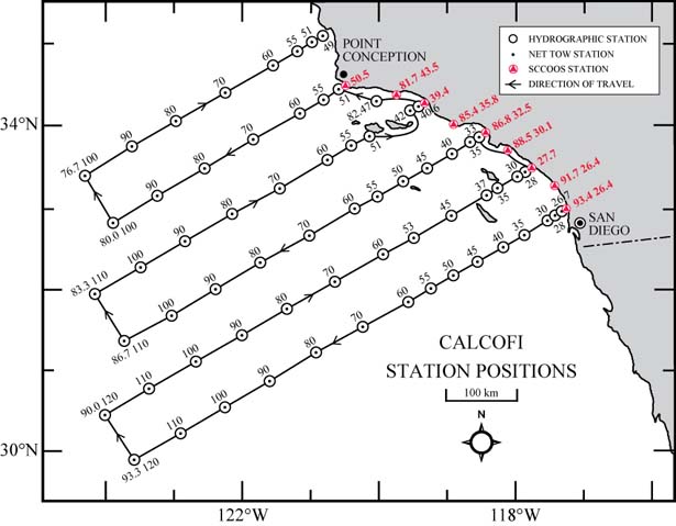
| Summary: | CalCOFI Leg 1: 75 stations occupied, 66 standard & 9 SCCOOS 20m isobath stations |
| Data Links: | 1207OS CTD Cast Files; FinalQC bottle-corrected CTD csvs, plots, & metadata |
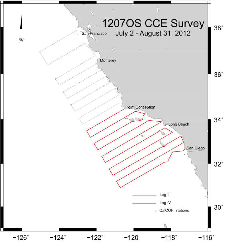
| Cruise Dates: | CalCOFI Leg 1: Mon 2 Jul, depart San Diego - Thu 19 Jul, return San Diego, CA (18 DAS) |
| CCE Leg 2: 22 Jul San Diego 01 Aug - Arrive San Diego, CA (11 DAS: mooring & near-island ops) | |
| CCE Leg 3: 02 Aug San Diego 16 Aug – Arrive Port Hueneme, CA (15 DAS: Acoustics & nightly plankton stas) | |
| CCE Leg 4: 17 Aug Port Hueneme 31 Aug – Arrive San Francisco, CA (16 DAS: CalCOFI stas north of Pt Conception) | |
| Ship: | RV Ocean Starr |
| Loading: | 10th Ave Marine Terminal, San Diego; Directions |
| Station plan: | Leg 1: 75 Standard (66 CalCOFI + 9 SCCOOS) |
| Leg 4: 38 CalCOFI stas of north of Pt Conception (see 113 station map) | |
| Instructions: | NOAA Cruise Instructions (pdf) |
| Cruise Map: | 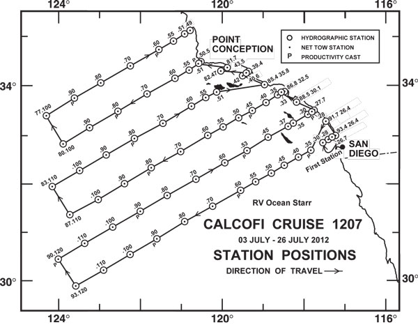 |
| Contacts: | Sam McClatchie, Chief Scientist, NOAA-NMFS |
| Amy Hays, Cruise Leader, NOAA-NMFS | |
| Jennifer Rodgers-Wolgast, SIO Technical Coordinator, SIO-IOD |
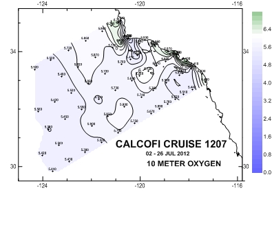
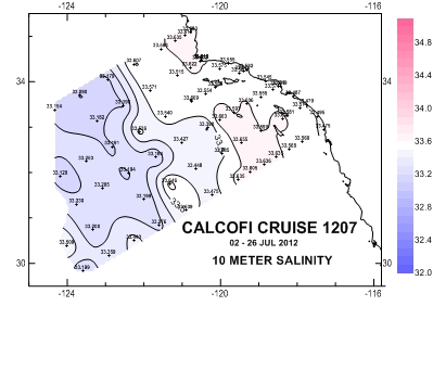
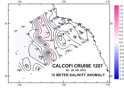
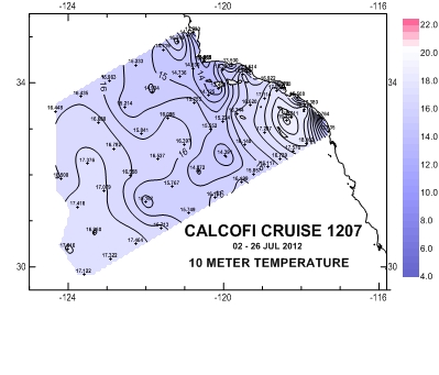
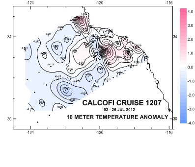
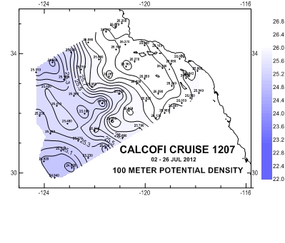
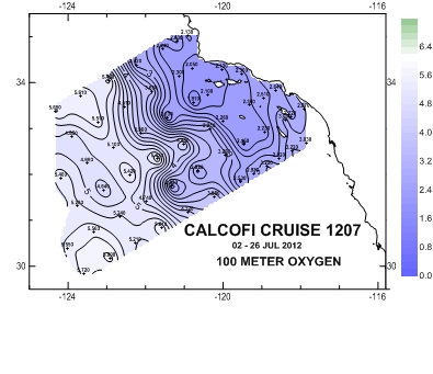
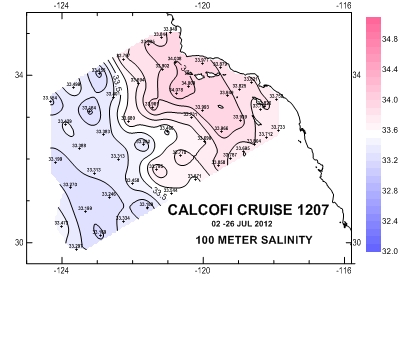
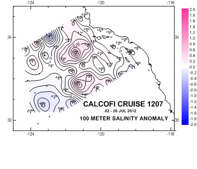
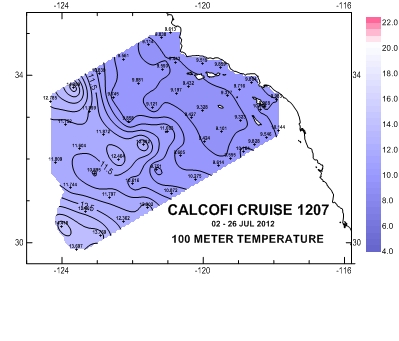
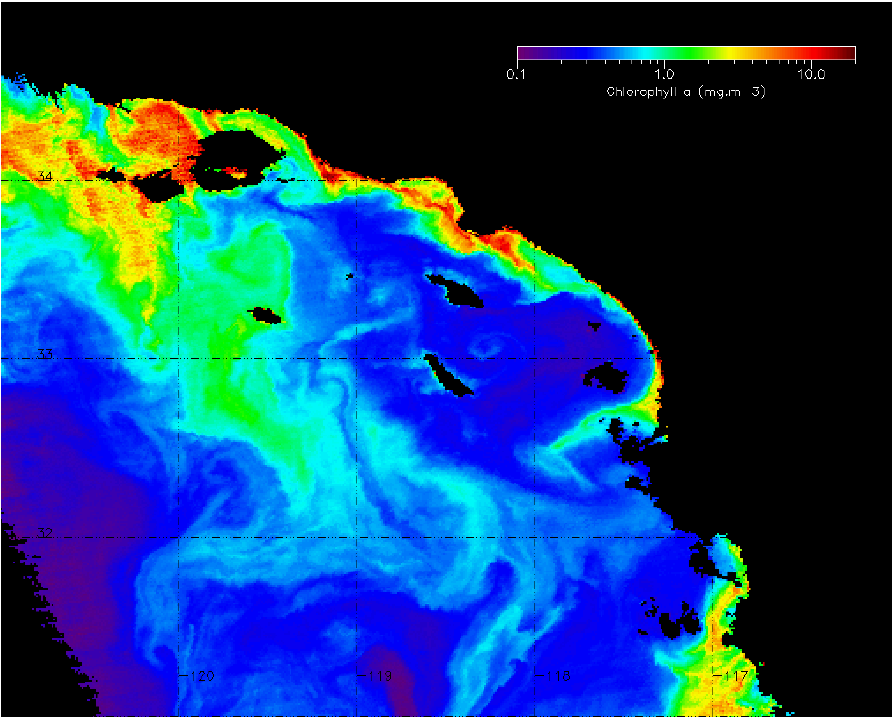
Please note that the anomalies are based on 50-year harmonics and that these data are direct from the CTD and have not gone through thorough quality control checks. They are presented to give a general impression of current conditions. Final data plots will be published after all data are processed.
 |
 |
 |
 |
 |
 |
 |
 |
 |
 |
 |
 |
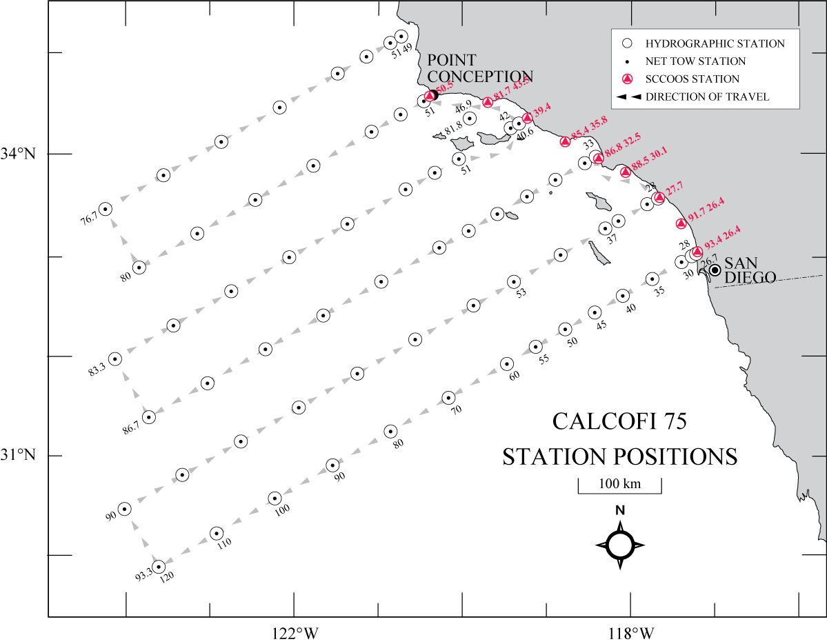
Clickable Station Data Map
This map may not reflect the actual cruise track and stations completed.
 |
| CTD Processing Summary CalCOFI 1207OS CTD Data (reprocessed Mar 2017, adding data quality code columns) | |||
| Download 1207OS CTD raw cast files zipped | Download 1207OS FinalQC CTD + bottle data | ||
| General CTD Notes - data acquisition notes, logistics, processing - see below | |||
| CTD sensor corrections derived by comparing 4 secs of CTD sensor data (prior to bottle closure) to bottle samples | |||
| Dual T, S, & O2 | Primary Sensor | Secondary Sensor | |
| Salinity offset (bottle - CTD salinity; > 350m only; Seabird SBE4) | -0.0066 | -0.0037 | |
| Oxygen mL/L (dual Seabird SBE43) | y = 1.0092x - 0.035 R² = 0.9995 |
y = 1.0087x - 0.339 R² = 0.9997 |
|
| Oxygen umole/Kg (dual Seabird SBE43) | y = 1.0124x - 1.4997 R² = 0.9995 |
y = 1.0118x - 1.443 R² = 0.9996 |
|
| Single sensors | |||
| Nitrate - ISUS 4sec ave voltage vs Bottle Nitrate (Satlantic MBARI-ISUS v2) | y = 29.052x - 8.422 R² = 0.9932 |
||
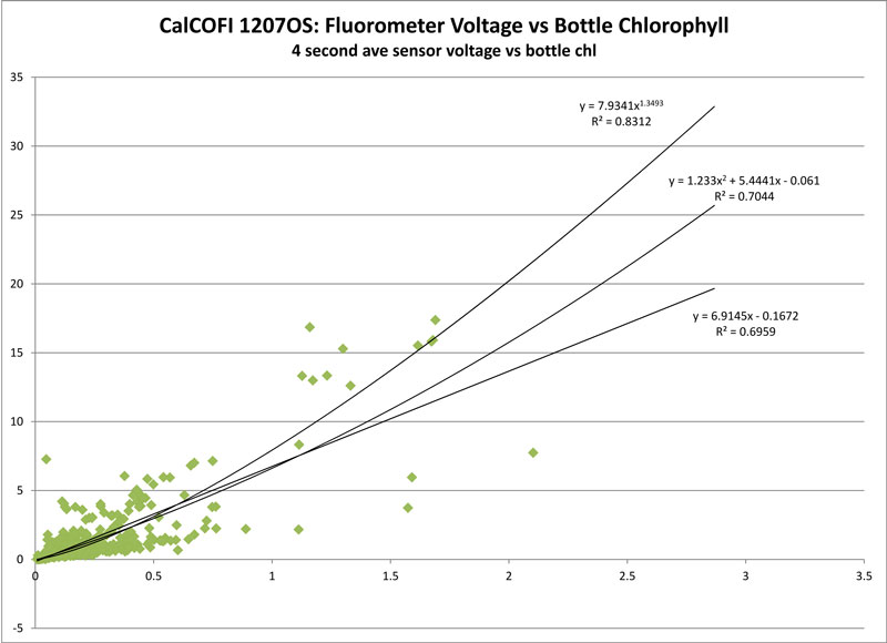
| Fluorometer - power, polynomial & linear regressions |
y= 7.9341x1.3493 R² = 0.8312 |
y= 1.233x2 + 5.4441x - 0.061 R² = 0.7044 |
y = 6.9145x - 0.01672 R² = 0.6959 |
 |
 |
||
") |
") |
||
 |
 |
||
|
General Note on 1207OS CTD Casts & Processing; 2017 reprocessing notes added 09Mar2017 reprocessed, adding data-quality code columns, and data codes on bad or missing data ("9") or questionable data ("8"). Data values should not have changed from the 2014 Final CTD data. But the column number on updated CTD.csvs has changed from 65 to 82. Refer to the CTD.csv data format webpage: 65-column index; 82-column index 1). Sailing on RV Ocean Starr. Wanting to test the CTD winch and wire, the first station was 93.3 30.0. Prior to the first cast, a eight was put on both winches to pay out enough to rewrap the drums and test hydraulics. Everything appeared fine so a full 515m CTD cast was performed. 2). On cast 2, a strand of the CTD wire broke at 515m, more broke as the CTD was raised so the bottle closures were aborted. Only the 515m terminal bottle was closed. July 3rd 2012 3). Since the CTD conductive wire was bad, the ship returned to San Diego and the cruise was postponed till new wire could be shipped & installed. The Cruise resumes after 7 days, on July 10th 2012. 4). Cast 5, SCCOOS sta 91.7 26.4 5m bottle did not close. The CTD was sent back to 5m after the surface bottle was closed and another 5m bottle was closed. Bottle #1 broke during recovery. 5). Cast 11 - ISUS dropout at 150m to 315m during the downcast. 5a). Cast 18 - 382m bottle salt looks bad, removed 6). Cast 21 - shallow chlorophyll max; ISUS dropout 214-276m downcast. 6a). Cast 25 - ISUS dropout at 214-270m downcast 7). Cast 32 - ISUS battery not working - data coded "9". Changed after cast. 8). Cast 37 - ~800m Santa Monica Basin Station, altimeter flakey so rosette may have touched bottom. Secondary O2 sensor data on upcast looks bad - will be replaced. Upcast secondary conductivity-salinity sensor data also look questionable; both secondary salinity and secondary oxygen data coded "8" on upcast. Primary sensor data look fine. 9). Cast 38 - new SBE43 O2 sensor installed on secondary O2 channel pre-cast. 10). Cast 39 - 40m bottle did not close, sent back down to 40m to get water after surface bottle was closed. 11). Cast 45 - extra LTER 10m bottle forgotten, CTD went back down after surface closure for the extra 10m bottle. 12). Cast 50 - rough weather begins...through cast 53 13). Cast 62 - upcast data may be compromised by jellyfish being sucked into the pump on the upcast. Data between 470-380m on upcast looks fishy. 14). Rough weather again Cast 64-69.. 15). Cast 66 - extra bottle fired at 240m by mistake, skipped. 87m bottle missed so CTD-rosette was lower back down after missing that depth. 16). Cast 69 - ISUS voltage dropout 371-438m downcast. 17). Cast 72 - extremely calm sea conditions. ISUS voltage dropout 243-322m downcast. Salinity & oxygen upcast data look bad from 33-0m, biofouling suspected. Small fuel leak delayed secchi after Bongo net tow. 18). Cast 73 - ISUS dropout 251-320m downcast.
|
|||
CRUISE INSTRUCTIONS (Complete pdf)
Ship: R/V Ocean Starr
Cruise Number: 1207-OS
Cruise Dates: July 2 – August 31, 2012
Cruise Title: California Current Ecosystem (CCE) Survey.
Study Area: US/Mexican border to San Francisco, with variable transect lengths.
Itinerary:
- Leg 1: 2 JUL San Diego 19 JUL – Arrive San Diego, CA 18 DAS
- Leg 2: 22 JUL San Diego 01 AUG - Arrive San Diego, CA 11 DAS
- Leg 3: 02 AUG San Diego 16 AUG – Arrive Port Hueneme, CA 15 DAS
- Leg 4: 17 AUG Port Hueneme 31 AUG – Arrive San Francisco, CA 16 DAS
Total 60 DAS
Sponsoring Institution:
- NOAA/NMFS, Southwest Fisheries Science Center (SWFSC)
- Fisheries Resources Division (FRD)
| CalCOFI-CCE 1207 Legs 1 & 2 | CCE Island Wake Survey Area Leg 2 | CalCOFI-CCE 1207 Legs 3 & 4 |
 |
 |
 |
| Refer to the final Cruise Instruction pdf for details; click images for larger maps. | ||
Cruise Description and Objectives:
- To conduct continuous underway sampling of surface waters. Temperature and salinity will be automatically logged by computer with the output from the GPS navigational unit.
- To contribute to ongoing assessment of pelagic fish stocks between San Diego and San Francisco, California.
- To collect information the size distribution and species composition of pelagic fish for acoustics ground truth information using trawling.
- To monitor environmental conditions within the CCE survey area.
- To record continuous acoustic targets obtained with a multi-frequency Simrad EK-60 scientific sounder.
- To service and move three moorings on CalCOFI line 90.
- To carry out an intensive field survey of island wakes around San Clemente and Catalina Islands, and south of San Nicolas Island, to detect hotspots of production supporting juvenile sardine and other juvenile fish.
Chief Scientist: Sam McClatchie, SWFSC (858) 546-7083, This email address is being protected from spambots. You need JavaScript enabled to view it.
PLAN OF OPERATIONS
1.0 OPERATIONS
The Ocean Starr will conduct operations from south to north along the west coast from San Diego to San Francisco, CA. The April CCE Survey was conducted as a two ship synoptic survey of the western US coast of North America. The current July survey extends the survey into the summer season, repeating most of the April transect lines of the April survey, south of San Francisco, applying the same methodologies, but incorporating time to (1) retrieve and service two oceanographic moorings, and (2) to carry out some intensive sampling of island wakes near the Catalina and San Clemente Islands, and to the south of San Nicolas Island.
- During leg 1, the Ocean Starr will conduct standard CalCOFI operations on the basic six line/75 station grid.
- During leg 2, operations will focus on collaborative mooring operations with Scripps Institution of Oceanography and intensive sampling around Catalina and San Clemente Islands, and to the south of San Nicolas Island, as mentioned above.
- During leg 3, plankton stations will be limited to night hours to permit continuous acoustic running during daylight. Plankton sampling of this area, south of Point Conception, will recently have been done by the preceding CalCOFI survey. Each night time plankton station on leg 1 will comprise CTD, pairovet, bongo and manta tows at the same location.
- During leg 4, north of Point Conception, full station work will be carried out in daylight and at night.