|
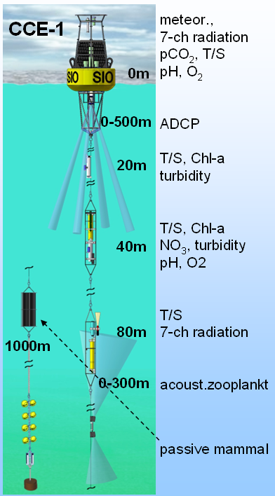
CalCOFI Station 80.80: lat 33° 29.0' N lon -122° 32.0' W (33.48333 -122.53335) is one of the primary station occupied on CalCOFI quarterly hydrographic survey cruises for over 70yrs. In March 06, 2011, a mooring (CCE-1) was deployed on sta 80.80. Real-time data can be viewed in the data section, and the sensor layout is shown in the diagram. The surface buoy is equipped with a meteorological sensor package providing air pressure, temperature, and wind speed, furthermore a CO2 system that measures CO2 concentration of the atmosphere and the surface water, and sensors for water temperature, salinity, oxygen concentration, and an acoustic doppler current profiler for water currents in the upper 500m. Subsurface sensors at various depths in the upper 80m measure temperature, salinity, chlorophyll concentration, water turbidity, pH, oxygen concentration, nitrate concentration, and cumulative biomass via radiometers. The mooring also contains an active acoustic sensor for zooplankton abundance in the upper 300m. A passive acoustic recorder for marine mammal sounds is not installed at the fifth deployment of CCE-1, as it was in the third and fourth at 1000m depth. The water depth is approximately 4000m, and the lower 3000m of the mooring consist of a stretched line that keeps the system under tension as waves and currents pull on it. (info courtesy of CCE Project & mooring.ucsd.edu) |
 |
 |